i-Tree Eco Sample Inventories
The Eco sample option is typically used for projects where it is not practical to inventory every tree in the study area such as for an assessment for an entire city, county or a region. Instead of collecting data for all trees, you will be collecting data within random plots that are located throughout your study area.
Model estimates and the accuracy of the estimates – standard error - are based on sampling. The sample option is also used for studies where vegetation is dense, such as in forests and natural areas, and data collection is more feasible using sampling protocols.
New sample project features
The Eco sample option has several improvements including:
- Flexible tree and plot data collection options - Tree species, tree DBH, percent of plot measured and tree cover percentage are minimum sample project requirements.
- Forecast scenario modeling - Forecast future forest structure and some ecosystem services based on multiple factors including tree growth, mortality and other user inputs.
- Reports - Numerous updated reports are available along with new individual tree detail reports for inventoried trees.
- Shrub avoided runoff effects - are now estimated for projects with optional shrub data collected.
Sample project options
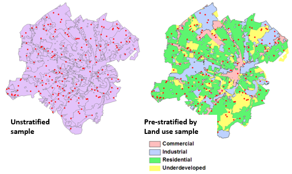
There are multiple ways that an Eco sample project can be set up. You should consider present and future objectives, while also considering available time and resources when deciding on how to design your sample project. Sample projects can be unstratified where the study area and analysis is treated as one area, or subdivided into units that allow for comparison of results between neighborhoods, political boundaries, land uses or other management units of interest.
The Eco v6 User Manual further discusses the advantages and limitations of sample options, and individual guides provide detailed instructions. See page 6.
Sample Plots
Plot quantity - The number of sample plots needed for an Eco project depends on the desired accuracy, and vegetation characteristics of the study area. Typically, 200 plots will produce about a 10% standard error for the total number of trees. Estimations are less certain with smaller samples.
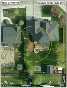
Plot size - The size of sample plots are usually .1 acre in size - a circle with a 37.2 foot radius. However, plot size is flexible and can be adjusted if desired.
Plot Maps - Field data collection crews typically locate field plots using maps indicating plot location. Aerial photographs and digital maps help with locating plots and features. Plot center may fall in public land, private land, or on the border of different land ownerships and land-use types.
- Effect of Plot and Sample Size on Timing and Precision of Urban Forest Assessments
- See the Eco Project Planning and Management Resources section for helpful resources such as example notification letters, management guides, equipment lists, maps and more.
Tree and plot data options
An Eco sample project requires that data is collected not only for trees and shrubs (optional), but also characteristics of the plot such as percentage of tree cover and land-use. Eco v6 sample project users can now decide which tree and plot data measurements they want to collect for their project beyond the minimum requirements. Project managers should consider carefully the relationship of recommended tree data measurements which will improve the model’s estimates significantly.
- Eco data variables and ecosystem services relationships document (pdf)
- Data Limitations Guide (pdf)
- Sample project data collection options (pdf)
- Eco v6 model basics & tree data model function relationships - Visit the Eco overview page
Field data collection options
Eco v6 users can use the mobile data collection system or paper field data collection forms which can then be manually entered into the Eco interface. The old PDA utility is not functional for Eco v6 data collection. Users working with older PDA devices can use the Eco v5 legacy application for data collection and later upgrade their project into Eco v6 for processing.
- Example Eco v6 plot data collection link - A example link that will open the mobile data collection form for exploration in browser.
- Eco Guide to Collecting Data with a PDA using Eco v5 (pdf)
- Paper collection forms & Eco v6 species list - See the i-Tree Eco v6 Resources section
Why consider an Eco sample project
Depending on your objectives and available resources, an Eco sample projects offers a more comprehensive understanding of the urban or rural forest – including both publicly and privately managed trees. Quantifying forest structure and associated benefits has enabled many Eco sample project users to improve strategic planning and management in numerous ways including:
- Recognizing trees as green infrastructure.
- Integrating trees in sustainability programs.
- Justifying management activities and expenses.
- Advocating for tree preservation or canopy augmentation strategies.
- Justifying further assessment studies or programs.
- Integrating trees in storm water management, climate adaptation strategies and other action plans.