GLRI Forest Planning for Watershed Health
Description
This is the home page for the Great Lakes Restoration Initiative (GLRI) project titled Urban Forest Enhancements of Ecosystem Services (hereafter referred to as "GLRI Forest Planning"). This project is intended to facilitate forest planning for water resource stewardship, reducing runoff, and improving water quality in the Great Lakes.
This project assessed 30 near-shore watersheds dominated by urban land uses throughout the Great Lakes. As described on the GLRI Projects index:
"Assessments are performed to determine the impact and value of current vegetation and impervious surfaces on the quantity and quality of storm water discharge from the watershed, developing maps of locations to sustain or enhance tree cover to improve storm water treatment within each watershed."
Objectives
This project has five objectives, accomplished using a variety of i-Tree models:
- Determine the impact and value of current vegetation and impervious surfaces on hourly stream flow, runoff, and water quality (using i-Tree Hydro);
- Quantify potential space within each watershed to enhance tree cover (using i-Tree Landscape);
- Determine future impacts of changes in vegetation and impervious surfaces on stream flow, runoff, and water quality (using i-Tree Hydro);
- Provide tree species recommendations for each watershed to maximize tree impacts on reducing runoff (using i-Tree Species); and
- Provide maps of nutrient hotspot and buffering locations, to sustain or enhance tree cover for optimal water quality benefits from trees within each watershed (using i-Tree Buffer).
Watershed assessments include a chapter dedicated to each of these objectives. Results from each watershed assessment are available below in a summary flyer highlighting key findings, along with technical reports that describe each model's analysis and resulting decision-support information. Additional data is provided to support management efforts, including GIS files of nutrient hotspots.
Reports
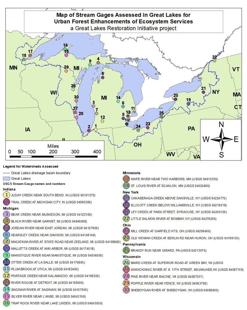
Watersheds were selected for assessment in collaboration with GLRI interagency representatives. Selections focused on active USGS stream gauges in GLRI's Areas of Concern or specific high-interest watersheds, near Great Lakes or densely populated areas, and of a scale (approximately 10-100 square miles) recommended for modeling using i-Tree Hydro. A GIS layer of this project's 30 stream gauges analyzed is available for download.
Indiana
#2 - Michigan City - Trail Creek (USGS 04095300) - Report - GIS Data
#1 - South Bend - Juday Creek (USGS 04101370) - Report - GIS Data
Michigan
#8 - Ann Arbor - Malletts Creek (USGS 04174518) - Report - GIS Data
#6 - * Davison - Kearsley Creek (USGS 04148140) - Report - GIS Data
#13 - Detroit - River Rouge (USGS 04166500) - Report - GIS Data
#4 - * Garnet - Black River (USGS 04046000) - Report - GIS Data
#5 - * Jordan - Jordan River (USGS 04127800) - Report - GIS Data
#12 - * Kalamazoo - Portage Creek (USGS 04106300) - Report - GIS Data
#15 - * L'Anse - Silver River (USGS 04043150) - Report - GIS Data
#10 - * La Salle - Otter Creek (USGS 04176605) - Report - GIS Data
#16 - * Lake Linden - Trap Rock River (USGS 04043050) - Report - GIS Data
#9 - * Manistique - Manistique River (USGS 04056500) - Report - GIS Data
#3 - Muskegon - Bear Creek (USGS 04122100) - Report - GIS Data
#14 - * Saginaw - Saginaw River (USGS 04157005) - Report - GIS Data
#11 - Utica - Plum Brook (USGS 04163400) - Report - GIS Data
#7 - * Zeeland - Macatawa River (USGS 04108800) - Report - GIS Data
Minnesota
#18 - * Scanlon - St. Louis River / (USGS 04024000) - Report - GIS Data
#17 - * Two Harbors - Knife River (USGS 04015330) - Report - GIS Data
New York
#22 - * Bombay - Little Salmon River (USGS 04270200) - Report - GIS Data
#19 - * Dansville - Canaseraga Creek (USGS 04224775) - Report - GIS Data
#21 - Syracuse - Ley Creek (USGS 04240120) - Report - GIS Data
#20 - Williamsville - Ellicott Creek (USGS 04218518) - Report - GIS Data
Ohio
#23 - Garfield Heights - Mill Creek (USGS 04208460) - Report - GIS Data
#24 - Huron - Old Woman Creek (USGS 04199155) - Report - GIS Data
Pennsylvania
#25 - Girard - Brandy Run (USGS 04213075) - Report - GIS Data
Wisconsin
#29 - * Fence - Popple River (USGS 04063700) - Report - GIS Data
#26 - * Green Bay - Baird Creek (USGS 040851325) - Report - GIS Data
#27 - Milwaukee - Kinnickinnic River (USGS 04087159) - Report - GIS Data
#28 - Racine - Pike River (USGS 04087257) - Report - GIS Data
#30 - Sheboygan - Sheboygan River (USGS 04086000) - Report - GIS Data
* Calibration limitations were encountered in watershed listed with an asterisk. This affects the i-Tree Hydro analysis in Chapter 1. Calibration limitations arise in these watersheds because they are significantly influenced by processes that are difficult to simulate, such as mismatching weather data and streamflow data, seasonal snowmelt regimes (simulated but with simplifications), or the impact of seiches on rivers near Great Lake shorelines (not simulated). Absolute values of predicted flows for these watersheds have poor or unknown accuracy, but the relative changes in surface runoff between model scenarios capture accurate responses to the data available for each watershed's weather, topography, land cover, and surface hydrologic processes. These watersheds are assessed due to their relevance for GLRI objectives, limited alternative gaged watersheds nearby, and because all other Chapters' analyses (nutrient hotspot identification, plantable space identification, and species recommendations) are unaffected by the i-Tree Hydro calibration.
Additional Resources
Webinar
In July 2021, this project's key findings and products were presented and discussed in an i-Tree Online Workshop hosted by the Urban Natural Resources Institute as part of the i-Tree Online Workshop series. A recording of this webinar is available here:
To learn about future i-Tree webinars, subscribe to the i-Tree Newsletter for updates.
Factsheet
Best practices in urban watershed-scale forest planning for stormwater management were summarized in the July 2021 factsheet "Recommendations for Improving Watershed-Scale Water Quality & Quantity". This generalized guidance is based on the conclusions and recommendations from the 30 watershed reports available above. For more specific summaries, each watershed report has an executive summary which offers brief recommendations for each project objective.
Support
For questions or comments about this project, please reach out to us at info@itreetools.org.
Recommended Citation
Project citation
Kruegler, J., Coville, R.C., Nowak, D.J., Endreny, T.A. (2021, April 15). Great Lakes Restoration Initiative, Urban Forest Enhancements of Ecosystem Services. i-Tree Tools. https://www.itreetools.org/support/resources-overview/project-profiles/glri-forest-planning
Report citation (Detroit example)
Kruegler, J., Coville, R.C., Nowak, D.J., Endreny, T.A. (2021, April 15). Forest Planning to Reduce Runoff and Improve Water Quality in the River Rouge Watershed, Detroit, MI. Great Lakes Restoration Initiative, Urban Forest Enhancements of Ecosystem Services. https://glri.itreetools.org/michigan/detroit-river-rouge/
Acknowledgements
This project was made possible with funding from the U.S. EPA, U.S.D.A. Forest Service, and the Great Lakes Restoration Initiative. Model research, development, and support was contributed by Dr. Ted Endreny of SUNY College of Environmental Science and Forestry and from the Davey Institute.